
Page 78 - 卫星导航2021年第1-2合期
P. 78
Cheng et al. Satell Navig (2021) 2:2 Page 6 of 12
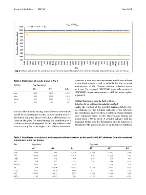
Fig. 5 Diferences between the coordinates at each SDCORS station at the epoch 2015.412 in the ITRF2005 aligned from the ERF and DRF frames
Table 2 Statistics of all results shown in Fig. 5 However, a nonlinear site movement model can achieve
a mm-level accuracy, and is suitable for the accurate
Statistic P DRF –P ERF (mm) maintenance of the Chinese national reference frame
in future. For regional CGCS2000, especially provincial
X 1 Y 1 Z 1
CGCS2000, linear maintenance is still the major option
Max 10.84 11.79 − 2.39 at present.
Min 9.21 11.38 − 3.32
Mean 10.73 11.65 − 3.10 Gridded horizontal velocity feld in China
Std 0.13 0.07 0.10
Selection for an optimal interpolation method
Under the control of the selected regional GNSS con-
trol stations for the Chinese national GNSS network,
and the other is constructing a non-linear site movement the coordinates and velocities at all the network stations
model for each reference station. A plate motion model is were estimated based on the observations during the
developed using the linear velocities at all reference sta- period from 1998 to 2010. A gridded velocity feld for
tions on the plate for transforming the coordinates of a mainland China is to be determined and its database is
station to the epoch required. It can only achieve a cm- provided to the general public to update the coordinates
level accuracy due to its neglect of nonlinear movement.
Table 3 Coordinate corrections at each regional reference station at the epoch 2015.412 obtained from the combined
adjustments in the two frames
Site P DRF (mm) P ERF (mm)
dE dN dH dE dN dH
YSSK 14.65 8.61 − 29.97 − 2.80 − 2.30 6.78
TIXI − 17.00 − 1.58 − 16.14 0.78 − 2.08 5.15
DAEJ 38.77 7.78 − 1.41 0.49 − 1.01 − 4.71
BJFS 2.30 2.72 − 18.75 2.46 − 1.34 − 6.24
WUHN 12.34 4.02 32.30 2.27 4.39 2.27
IISC 8.74 − 7.34 − 9.83 − 1.09 0.82 6.07
POL2 − 11.27 − 11.24 11.40 0.17 − 1.19 − 0.31
KIT3 − 17.87 − 10.32 25.79 − 3.64 − 2.14 8.49
ARTU − 1.81 − 10.43 5.84 − 1.72 0.16 − 0.95