
Page 74 - 卫星导航2021年第1-2合期
P. 74
Cheng et al. Satell Navig (2021) 2:2 Page 2 of 12
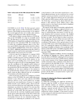
Table 1 Information on the ITRFs released after the ITRF97 control stations at the observation epoch from a com-
bined adjustment based on the constraint-free normal
Version GPS week Duration
equation systems provided by several IGS analysis cent-
ITRF2000 1043–1399 12 2 2001–11 4 2006 ers, for a better alignment between the two associated
ITRF2005 1400–1585 11 5 2006–5 30 2010 ITRFs with the GNSS stations and the control stations.
ITRF2008 1586–1800 5 31 2010–1 20 2016 Te third step is correcting the above-obtained coor-
ITRF2014 1801– 1 21 2016– dinates to the reference epoch 2000.0 using a plate
motion model or the linear velocity feld in mainland
China developed in this study.
CGCS2000 (Liu et al. 2014). Te frst approach cannot Te purpose of this paper is to introduce optimal meth-
achieve high accuracy of the transformed coordinates, ods or strategies for aligning a regional network to an
because of the limited velocity precision of the stations. ITRF and updating the CGCS2000 coordinates of sta-
Te second approach does not consider plate motions, tions by considering plate movement, to avoid the net-
leading to some distortion of the regional network. work distortion due to incorrect method. Te detailed
In this study, to obtain accurate positions of GNSS sta- procedure for aligning the regional network with an ITRF
tions in the CGCS2000, two steps are normally carried includes two steps. Te frst step is to select control sta-
out. Te frst step is to process the observations of the tions considering consistent of their movement with their
GNSS stations to obtain their coordinates at the observa- corresponding plate. Te second step is to obtain the
tion epoch in their associated ITRF. Te second step is coordinates of the stations of the regional network in the
to correct the coordinates obtained above to the refer- associated ITRF under control of the selected control sta-
ence epoch 2000.0 using a plate motion model or a linear tions. For updating the regional CGCS2000 frame, addi-
velocity feld in mainland China. If the above ITRF is not tional step is needed, to transform the coordinates of the
the ITRF97, additional transformation into the ITRF97 is stations in the ITRF to the CGCS2000 using their veloci-
needed using the transformation parameters at the epoch ties and seven transformation parameters between the
2000 and their rates between the two ITRFs. associated ITRFs.
In the frst step, for the alignment of a regional GNSS Tis paper is organized as follows. Section 2 introduces
network with an ITRF, regional control stations are the strategies for aligning the Chinese regional GNSS
needed. Currently, the most common method is to select network with the ITRF2005, including the determination
the International GNSS Service (IGS) stations in the of the criteria for the selection of GNSS reference stations
region and its surrounding areas, even their movement as the control stations of the Chinese regional network
trends do not agree with the corresponding plates. More- and the refnement of the coordinates of the selected ref-
over, the coordinates of the regional control stations at erence stations in the ITRF2005. In Sect. 3, the common
the observation time are obtained based on their veloci- interpolation methods for constructing a new gridded
ties provided in ITRF documentation. Tus the obtained velocity feld in mainland China are compared and ana-
coordinates are the mean positions of the stations in lyzed, and the accuracy of the updated CGCS2000 based
the period from the reference epoch to the observation on the movements obtained from the newly constructed
epoch, which are likely diferent from the real positions gridded velocity feld is evaluated. Section 4 gives sum-
of the stations at the observation time. mary and conclusions.
In the second step, to obtain the coordinates of GNSS
stations in the CGCS2000, the quasi-stable adjustment
method is used, which uses some selected CGCS2000 Strategy for aligning the Chinese regional GNSS
reference stations as the control stations for strongly network with an ITRF
tying the two associated frames. However, if a regional In GNSS data processing, the single-day solutions are
GNSS network covers diferent plates, which have dif- obtained using the GAMIT or Bernese software, then
ferent movement directions and magnitudes, the above some reference stations are selected as control sta-
adjustment can distort the network. To overcome this tions and used in a multi-day combined adjustment for
problem, the following procedure of three steps was aligning a regional network with an ITRF. Since GNSS
carried out in this study. Te frst step is determining single-day solutions can be obtained with most of the
the criteria for the selection of global control stations professional software packages, in this section we focus
for the quasi-stable adjustment in the ITRF, which only on the strategies for selecting control stations and obtain-
selects the stations that well represent the geometric ing their refned coordinates.
relationship between the two associated frames. Te
second step is estimating the positions of the selected