
Page 70 - 卫星导航2021年第1-2合期
P. 70
Han et al. Satell Navig (2021) 2:18 Page 8 of 10
reference frame points (Liu, 2019). About 10 monitor- accuracy depending on the length of the forecast time;
ing stations, 3 International GNSS Service (IGS) stations and the other is the autonomous solution on the satel-
in China and some other IGS stations around the world lite. Te EOP is essentially three Euler angles between
are involved in the BDCS. GNSS observations are mainly GCRS and GTRS. To solve for EOP the observations that
used at present, and other observations, such as VLBI, connect two reference systems are needed. Te satellites
SLR, may also be used. Te frame points are monitored need to observe celestial bodies, which refect the orien-
continuously and their coordinates are adjusted together tation of GCRS, and the ground stations, called anchor
with IGS stations. Te coordinates and velocities of frame stations, which refect the orientation of GTRS. In this
points will be determined regularly. case, the solution accuracy of EOP depends on not only
Te coordinates are in accordance with ITRF2014 at the astronomical observations but also the number and
−8
centimeter level. Te scale diference is about 1.1 × 10 . distribution of anchor stations. Similar to the mode with
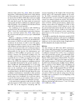
Table 2 shows the transformation parameters between the supports of MCS, the ground anchor stations have
the two coordinate systems (Liu, 2018), where mas is great impacts on the accuracy of the user’s positioning
the milliarcsecond and ppb is one part per 1,000,000,000 and timing.
9
(10 ) parts. It should be noted that the observation model of EOP
BDCS is a realization of GTRS, and its relationship in the autonomous operation mode must be established
with GCRS satisfes Eq. (12). At present, the implementa- within the BCRS framework, considering that celestial
tion accuracy of BDCS can only reach the magnitude of bodies are very far away and the scope of application of
centimeters. In the future, in order to meet the applica- GCRS is limited to the vicinity of the Earth.
tion needs with higher accuracy, we must realize BDCS
with millimeter accuracy, improve the accuracy of obser- BDS time
vations, use multi-source data, and continuously improve Te time reference for BDS Time (BDT) synchroniza-
the accuracy of reference frame points and EOP. EOP is tion, precise orbit determination and system operation is
indispensable for the precise orbit determination and BDT. Similar to GPS Time (GPST), BDT is diferent from
prediction of BDS satellites and precise time synchro- Coordinated Universal Time (UTC). It is a continuous
nization. However, the dynamical modeling error, the time scale without leap seconds. In the BDS Radio Navi-
so-called Coriolis force of non-inertial reference frame gation Satellite Service (RNSS), BDT is counted in Week
caused by the error of EOP, is not signifcant in the oper- Number (WN) and Seconds of Week (SOW). Te repeti-
ation mode supported by MCS. Although the orbit is tion period of WN in BDS is 8 times larger than that of
given in the GCRS, the positions of navigation satellites GPS, and the maximum of WN does not exceed 8192. In
are essentially determined by the ground monitor sta- the BDS Radio Determination Satellite Service (RDSS),
tions. Usually, the orbit determination arc is not long, BDT is counted in Year Number (YN) and Minutes of
about a few days, the systematic infuence of the EOP Year (MOY). Te zero point of BDT is UTC 00:00:00
error on the coordinates can be ignored because the on January 1, 2006. At this moment WN and SOW are
orbit parameters broadcast by the navigation satellite are equal to zero, YN is 6 and MOY is 480. Compared with
transformed back to the BDCS through almost the same the system times of GPS and Galileo, the choice of the
coordinate transformation. Essentially, in this operation zero point of BDT is not only for saving bytes, but also
mode the process of positioning and timing is determin- for being easier to remember. It is the beginning of the
ing the space–time coordinates of an unknown station year (Han et al., 2011).
or user by the known ground stations. High accuracy of Conceptually, BDT is an implementation of Terrestrial
EOP is not needed, and milli-arcsecond level is enough. Time (TT). According to IAU2000 Resolution B1.9, the
In the autonomous operation mode where the system following relationship holds between TT and TCG (Han,
loses the support of MCS, there are two ways to obtain 2017; Sofel et al., 2003):
the EOP: one is the long-term forecasting with the
Table 2 Seven parameters of conversion between BDCS and ITRF2014
Item T (mm) T (mm) T (mm) R in mas R in mas R in mas Scale
z
x
y
z
y
x
factor in
ppb
Value − 0.37 1.12 − 0.55 0.01 − 0.02 0.05 0.011
RMS 0.74 0.74 0.74 0.03 0.03 0.04 0.012