
Page 81 - 卫星导航2021年第1-2合期
P. 81
Cheng et al. Satell Navig (2021) 2:2 Page 9 of 12
especially in the alignment of a regional reference frame larger than 1 dm are shown in this fgure. From Fig. 7
with the CGCS2000 to obtain the positions of the GNSS we can see that inappropriate corrections result in the
stations in the CGCS2000, the regional network can be wrong tie to the CGCS2000, causing the GNSS network
distorted. distortion, especially in southwest China and northeast
Currently, two common methods for correcting the China. Te directions of the vectors agree well with the
coordinate of a GNSS station from the observation movement directions of the plate where the stations are
epoch to the CGCS2000 reference epoch are the quasi- located, and larger diferences occurred in the subplates
stable adjustment under the CGCS2000 and the plate whose motion is inconsistent with that of the subplates in
movement correction (Cheng 2017). In the frst method, middle China.
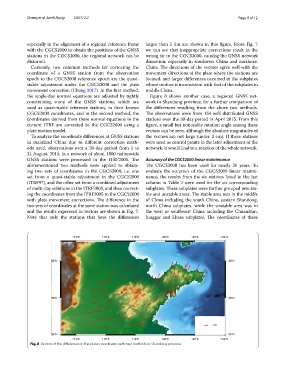
the single-day normal equations are adjusted by tightly Figure 8 shows another case, a regional GNSS net-
constraining some of the GNSS stations, which are work in Shandong province, for a further comparison of
used as quasi-stable reference stations, to their known the diferences resulting from the above two methods.
CGCS2000 coordinates, and in the second method, the Te observations were from 154 well distributed GNSS
coordinates derived from these normal equations in the stations over the 30-day period in April 2015. From this
current ITRF are corrected to the CGCS2000 using a fgure, a small but noticeable rotation angle among these
plate motion model. vectors can be seen, although the absolute magnitudes of
To analyze the coordinate diferences at GNSS stations the vectors are not large (under 2 cm). If these stations
in mainland China due to diferent correction meth- were used as control points in the later adjustment of the
ods used, observations over a 30-day period from 1 to network, it would lead to a rotation of the whole network.
31 August, 2015, in a network of about 1800 nationwide
GNSS stations were processed in the ITRF2005. Te Accuracy of the CGCS2000 linear maintenance
aforementioned two methods were applied to obtain- Te CGCS2000 has been used for nearly 20 years. To
ing two sets of coordinates in the CGCS2000, i.e. one evaluate the accuracy of the CGCS2000 linear mainte-
set from a quasi-stable adjustment in the CGCS2000 nance, the results from the six stations listed in the last
(ITRF97), and the other set from a combined adjustment column in Table 2 were used for the six corresponding
of multi-day solutions in the ITRF2005, and then correct- subplates. Tese subplates were further grouped into sta-
ing the coordinates from the ITRF2005 to the CGCS2000 ble and unstable areas. Te stable area was in the middle
with plate movement corrections. Te diference in the of China including the south China, eastern Shandong,
two sets of coordinates at the same station was calculated north China subplates. while the unstable area was in
and the results expressed in vectors are shown in Fig. 7. the west or southwest China including the Chuandian,
Note that only the stations that have the diferences Junggar and Lhasa subplates. Te coordinates of these
Fig. 8 Vectors of the diferences in the plane coordinates with two methods in Shandong province