
Page 80 - 卫星导航2021年第1-2合期
P. 80
Cheng et al. Satell Navig (2021) 2:2 Page 8 of 12
Construction of a gridded horizontal velocity feld geological areas, such as the Chuandian and Qinhai
The selection of sample points is important to the Tibet subplates, higher grid resolutions of 30′ × 30′
IDW performance. Usually at least four sample points and 15′ × 15′ were applied. The precisions of the whole
that are surrounding and closest to the point of inter- velocity field in the E, N directions were 0.78 mm/a
est are selected. Two common methods for search- and 0.95 mm/a, respectively.
ing such sample points are the linear search and the
area search. In this study the circle search method, Maintenance of the CGCS2000 with a linear velocity feld
which belongs to the category of area search, was used. Efect of inconsistent frames on a multi‑day solution
According to the distribution of the sample points Generally, GNSS observations are processed in a ground-
used in this study, most of them were within the circle based frame that is consistent with the space-based frame
with a radius from 1° to 3°. Thus the searching process that GNSS satellites are associated with. Te ground-
started from the radius of 1°. If there were more than based frame is determined by the control points selected
four sample points within the circle, the interpolation from the reference stations used in the construction of an
was performed, otherwise the searching process con- ITRF. Te space-based frame is determined by the earth-
tinued with the search radius of 2°, then 3° if needed. fxed coordinates of GNSS satellites in diferent ITRFs
Generally, the larger the radius of searching circle, the (see Table 1), and provided in IGS satellite ephemerides.
weaker the correlation between the sample points and When a solution is to be obtained from multi-day GNSS
the interpolation point and the poorer the accuracy of observations, the common practice is to obtain single-
the interpolated result will be. day solutions frst, then all single-day solutions are com-
The results of a 1° × 1° gridded velocity field in main- bined in the fnal adjustment. If the combination of these
land China were constructed using the above proce- daily solutions cannot remain the consistent between
dure. It should be mentioned that in some complicated the space-based frame and the ground-based frame,
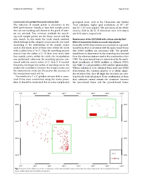
Fig. 7 Vectors of the diferences in the coordinates at the national GNSS stations that have the value larger than 10 cm obtained from the
quasi-stable adjustment and plate movement