
Page 90 - 卫星导航2021年第1-2合期
P. 90
Shi et al. Satell Navig (2021) 2:5 Page 6 of 13
6 m) 6 m)
Y ECI (×10 Number of visible satellites Y ECI (×10 Number of visible satellites
X (×10 m) X (×10 m)
6
6
ECI ECI
a b
6 m) 6 m)
Y ECI (×10 Number of visible satellites Y ECI (×10 Number of visible satellites
X ECI (×10 m) X ECI (×10 m)
6
6
c d
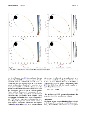
Fig. 4 The number of visible satellites of the spacecraft in SSTO orbit under diferent combinations: a BDS; b GPS + Galileo + GLONASS; c
GPS + Galileo + GLONASS + BDS (only MEO satellites); d GPS + Galileo + GLONASS + BDS
the C/N 0 (Capuano et al. 2016). According to the data only consider the ephemeris error, satellites clock error
from the Chang’E-5 T lunar returning program, when the and receiver noise ( E N ). According to the statistical value
spacecraft height is 10,000–60,000 km, σ R is 5.7–8.1 m of SISRE for each GNSS and the E N of 0.5 m in Table 3.
(single-diferencing C/A code) (Fan et al. 2015). Under (Montenbruck et al. 2018; Sadman and Hossam-E-Haider
certain conditions(non-fltered), a lower position error 2019; Xi et al. 2019), the following formula is used to cal-
needs a lower PDOP value which is dependent on the culate the position accuracy σ:
geometrical relationship between the navigation satellites
and the receiver, and the number of available satellites. σ = PDOP × (SISRE +E N ) (5)
t
As the height of the spacecraft increases, the 3D posi-
tion error will inevitably rise with the ascent of PDOP. For simplicity, the SISRE t is weighted according to the
To compare the position error under diferent GNSSs proportion of satellites in each system at time t.
combinations, the Signal-in-Space Ranging Error (SISRE)
and PDOP are used together to evaluate position accu- Doppler shift
racy. Te pseudorange error is from various sources in It is obvious that the Doppler shift should be considered
space segment, propagation segment and user segment in the design of receiver (Lorga et al. 2010). After esti-
(Acharya 2014; Parkinson 1995). In the current study, we mating the coordinates and velocities of the navigation