Page 89 - 卫星导航2021年第1-2合期
P. 89

Shi et al. Satell Navig             (2021) 2:5                                         Page 5 of 13


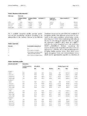
            Table 4  Receiver orbits elements
            Orbit type    Elements
                          Perigee altitude   Apogee altitude   Inclination (°)  Argument   Mean anomaly (°)  RAAN (°)
                          (km)          (km)                         of Perigee (°)
            SSTO            192.8       68,016.8      16.301         192.719        0                 309.684
            GEO at 125°   35,681.3      35,740.6      0.1186         90.847         78.2409            83.169
            GEO at 0°     35,788.1      35,788.1      0.111          0              123.352            89.859
            GEO at 240°   35,788.1      35,788.1      0.111          0              3.352              89.859


            No. k available navigation satellite position param-  coordinate system used in each GNSS, the coordinate of
            eter and the pseudorange calculated according to the   navigation satellite from diferent system must be con-
            ephemerides at that moment. Because of the diferent   verted to the same coordinate system before calcula-
                                                              tion (Jing et al. 2014). After transforming both sides of
                                                              the Eq. (4) and seeking the expected value, we can get
                                                                                         2
                                                              the  expression  E[dξdξ ] = Hσ   where  H =[QQ ]
                                                                                 T
                                                                                                         T −1
                                                                                         R
            Table 5  Scenario                                 and  dξ is the vector of position error and clock error,
                                                                      √
            Scenario                  Constellation composition  PDOP =  trace{H 3×3 } .  Without  considering  the
                                                              receiver clockerror, the 3D position estimation error can
            1                         BDS                     express as σ p = PDOPσ R , the σ R is the pseudorange error,
            2                         GPS + Galileo + GLONASS  including satellite position errors, clock ofset errors,
            3                         GPS + Galileo + GLONASS + BDS   signal propagation errors, and instrumentation errors,
                                        MEO (only MEO satellites)
            4                         GPS + Galileo + GLONASS + BDS  which can be approximately regarded as a function of


            Table 6  Synthetic results
            Scenario and orbit  Parameters
                                % of time position   C/N  dB·Hz                 Positioning error (m)
                                                  0
                                solvable
                                                Min       Max       Median      Min        Max         Median
            Scenario 1
              SSTO              28.4            23.68     50.11     39.35        1.41      1051.29     33.34
              GEO at 0°         71.4            28.76     49.2      40.86       33.98      1030.13     88.96
              GEO at 125°        8.7            28.76     48.16     36.11       45.95      1045.10     131.56
              GEO at 240°       72.0            28.76     48.16     43.60       36.99      1088.78     98.69
            Scenario 2
              SSTO              19.7            20.02     49.14     39.06        1.05       921.49     27.07
              GEO at 0°         18.5            21.70     47.76     48.16       52.19       805.47     103.30
              GEO at 125°       20.7            21.70     47.76     40.90       50.96       855.79     125.03
              GEO at 240°       23.6            21.64     47.76     40.98       43.13       854.95     103.53
            Scenario 3
              SSTO              37.8            20.02     49.61     38.30        0.93      1260.10     58.49
              GEO at 0°         55.4            21.70     48.16     38.71       37.47      1089.27     82.25
              GEO at 125°       52.9            21.70     48.16     40.77       34.47      1373.59     83.85
              GEO at 240°       57.6            21.64     48.16     40.78       30.73      1283.32     78.85
            Scenario 4
              SSTO              50.0            20.02     50.11     39.12        0.92       888.13     63.95
              GEO at 0°         97.0            21.70     49.21     40.87       27.58       199.98     51.83
              GEO at 125°       52.9            21.70     48.16     40.77       34.47      1373.59     83.85
              GEO at 240°       97.2            21.64     48.16     42.44       26.78       715.43     57.99
   84   85   86   87   88   89   90   91   92   93   94