
Page 78 - 《高原气象》2022年第5期
P. 78
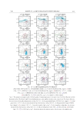
5 期                   陈豫英等:贺兰山东麓不同量级暴雨过程的环流特征和概念模型                                         1171


                                          图6  贺兰山东麓不同量级暴雨过程的天气学概念模型
                      为水平流场,G和D为高低压中心,彩色区颜色越深,强度越大;(a~c)中 为200 hPa位势高度(单位:dagpm),                   为散度
                                                                                               -1
                                                                                             -5
                             -6 -1
                    (单位:×10 s ),彩色区为高空急流;(d~l)中 为500 hPa位势高度(单位:dagpm), 为涡度(单位:×10 s ), 为比湿
                                   -1
                          (单位:g·kg ), 为槽线或切变线,彩色区为低空急流;(m~o)中 为海平面气压(单位:hPa),                 为冷锋,
                                                                   -1
                                   为K指数(单位:℃),      为CAPE(单位:g·kg ),红点为暴雨中心,彩色区为暴雨区
               Fig. 6  The synoptic conceptual model of different grades of rainstorm processes in the eastern foot of the Helan Mountain.  is the
               horizontal airflow. The letters G and D denote the high pressure center and low pressure center,respectively. The deeper color area,
               the more intense the key physical parameters. In Fig. 6(a)~(c), is the geopotential height of 200 hPa(unit:dagpm),  is diver‐
                 gence(unit:×10 s ),the color area denotes the high -level jet area;In Fig. 6(d)~(l), is the geopotential height of 500hPa
                             -6 -1
                                                                        -1
                                            -1
                                          -5
               (unit:dagpm),  is vorticity(×10 s ), is specific humidity(unit:g·kg ), is the trough line or shear line,the color area
                 denotes the low -level jet area;In Fig. 6(m)~(o), is the sea level pressure(unit:hPa),  is the cold front,  is K index
                                                -1
                   (unit:℃),    is CAPE(unit:g·kg ),the red dot denotes the rainstorm center,the color area is the rainstorm area