
Page 127 - 卫星导航2021年第1-2合期
P. 127
Xia et al. Satell Navig (2021) 2:8 Page 13 of 19
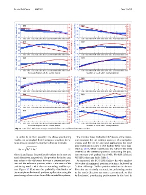
Fig. 13 C/N0 (blue) and elevation angle series (red) of BDS, GPS, Galileo and GLONASS satellites
In order to further quantify the above positioning Te Circular Error Probable (CEP) is one of the impor-
results, we calculated their horizontal position devia- tant measures for the position accuracy of a navigation
tions at each epoch by using the following formula: system, and for the air and land applications the most
used statistical measure is 95% Radius (R95) value (Spe-
2 2 (7) cht et al. 2019), which is defned as the radius of the circle
δ H = δ E + δ N
centered at the reference position, containing the posi-
where δ E and δ N are the position deviations in the east and tion estimate with probability of 95%. Te R68 (2D) and
north directions, respectively. Te position deviation used R95 (2D) values are list in Table 3.
here refers to the diference between a determined posi- As expected, the BDS/GPS/Galileo, has the smallest
tion and the reference position, which is the mean of the R95 value of horizontal position solutions, followed by
positioning results with the corresponding satellite sys- Galileo. Although Galileo position solutions in the east
tem. Figure 16 illustrates the probability distribution of direction are relatively scattered, its positioning results
the smartphone horizontal positioning deviation using the in the north direction are more concentrated, so that
pseudorange observations from diferent satellite systems. its horizontal positioning performance is the best in