
Page 80 - 《高原气象》2025年第5期
P. 80
高 原 气 象 44 卷
1198
图7 各主控天气型下沿86°E -93°E平均的纬向(a~c)及29°N -33°N平均的经向(d~f)环流(矢量)和水平散度(填色,
单位: ×10 s )相对于1979 -2018年秋季气候态差异的垂直剖面
-1
-5
(a, d) P1, (b, e) P2, (c, f) P3, 灰色填色表示青藏高原地形, 各图中两条红色竖线之间的区域表示高原中部范围
-5
-1
Fig. 7 The vertical profile of the differences between the circulation (vectors) and horizontal divergence (shaded, unit: ×10 s )
of the zonally averaged (a~c) along 86°E -93°E and meridionally averaged (d~f) along 29°N -33°N and the climatic
mean during autumn of 1979 -2018.(a, d ) P1, (b, e) P2, (c, f) P3. The gray color fillings indicate the
topography of the Qinghai-Xizang Plateau, and areas between the two red vertical lines in each
sub-figure indicate the range of the central Qinghai-Xizang Plateau
表1 WRF-Lake模式的参数化方案设置
Table 1 Model configurations of parameterization
schemes in WRF-Lake model
物理过程 参数化方案
微物理 WRF single-moment 6-class scheme
积云参数化 Grell-Devenyi ensemble scheme
长波辐射 RRTM scheme
短波辐射 Dudhia scheme
边界层 Noah scheme
陆面 YSU scheme
12:00 至 26 日 12:00, 2000 年 9 月 8 日 21:00 至 9 日
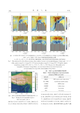
图8 WRF-Lake模式嵌套区域设置及地形高度(单位: m)
21:00, 2006 年 9 月 23 日 00:00 至 24 日 00:00; P3 型
Fig. 8 Nesting area and topographic height of
WRF-Lake model. Unit: m 下: 2004 年 10 月 25 日 18:00 至 26 日 18:00; 2005 年
2003 年 9 月 10 日 18:00 至 11 日 18:00, 2006 年 9 月 10 月 30 日 12:00 至 31 日 12:00; 2006 年 10 月 23 日
11 日 21:00 至 12 日 21:00; P2 型下:1989 年 9 月 25 日 21:00 至 24 日 21:00。继而利用 WRF-Lake 湖-气耦