
Page 85 - 《高原气象》2022年第5期
P. 85
高 原 气 象 41 卷
1178
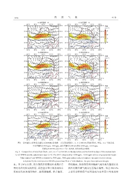
图2 盆西型(a~d)和盆东型(e~h)RPHRs发生前一天以及持续第1、2、3天500 hPa风场(风羽,单位:m·s )的合成
-1
红色等值线为5850 gpm、5880 gpm,蓝色等值线为200 hPa高度12500 gpm、12550 gpm,
-1
阴影表示200 hPa高度30 m·s 以上的风速,棕色实线表示槽线
Fig. 2 Composition of wind field(barb,unit:m·s )at 500 hPa on the day before and the first three days of the western basin
-1
(a~d)RPHRs and the eastern basin type(e~h). The SAH is depicted by 12500 gpm,12550 gpm isolines of geopotential height
(blue contour)and WPSH is depicted by 5850 gpm,5880 gpm isolines with red contour;the upper level jet stream
-1
is depicted by the wind speed at 200 hPa greater than 30 m·s with shadows,the grey lines represent troughs
东。在 130°E 以西,西太副高在西部型中表现出自 脊线偏南,使得副高外围偏南气流的水汽输送以及
南向北经向伸展的特征,而在盆东型中则表现出自 其西北侧冷暖气流交汇区偏东偏南。结合 200 hPa
东向西纬向发展的特征,且强度偏强,脊点偏东, 上盆东型中的高空西风急流与南亚高压均比西部