
Page 23 - 《高原气象》2022年第5期
P. 23
高 原 气 象 41 卷
1116
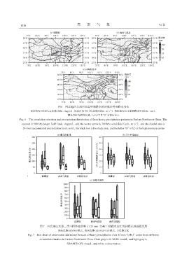
图6 西北地区东部不同类型强降水的环流形势和降水分布
等值线为500 hPa高度场(单位:dagpm),风向杆为700 hPa风场(单位:m·s ),阴影区为24 h累积降水量(单位:mm),
-1
黑色方框为研究区域,(c)中字母“G”为高压中心
Fig. 6 The circulation situation and precipitation distribution of three heavy precipitation patterns in Eastern Northwest China. The
contour is 500 hPa height field(unit:dagpm),and the vector arrow is 700 hPa wind field(unit:m·s ),and the shaded area is
-1
24-hour accumulated precipitation(unit:mm),the black box is the study area,and the letter“G”in(c)is the high pressure center
图7 西北地区东部三类不同环流形势下≥25 mm·(24h) 强降水的实况和模式预报箱线图
-1
深灰色是ECMWF模式,浅灰色是GRAPES-GFS模式,白色是实况
-1
Fig. 7 Box chart of observation and model forecast of heavy precipitation over 25 mm·(24h) under three different
circulation situation in Eastern Northwest China. Dark grey is ECMWF model,and light grey is
GRAPES-GFS model,and white is observation