
Page 78 - 《高原气象》2022年第1期
P. 78
高 原 气 象 41 卷
76
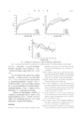
图8 水汽输送过程中轨迹的高度(a)、温度(b)和相对湿度(c)随时间的变化
Fig. 8 The change of track height(a),temperature(b)and relative humidity(c)with time during water vapor transport
率为 28%。三条东南路径,10天前主要水汽来源出 during three extreme rainfall events over the Mackenzie River Ba‐
现在贵州、湖南等地,向西北方向输送至三江源, sin[J]. Journal of Hydrometeorology,6(4):423-440. DOI:10.
1175/JHM430. 1.
三条路径的水汽输送贡献率分别为 23%、23% 和
Challa V S,Indrcanti J,Baham J M,et al,2008. Sensitivity of atmo‐
26%。
spheric dispersion simulations by HYSPLIT to the meteorological
(4) 综合两次暴雨过程,通过对气块三维追踪 predictions from a mesoscale model[J]. Environmental Fluid Me‐
分析得到,三江源地区 500 hPa 上主要的水汽输送 chanics,8(4):367-387. DOI:10. 1007/s10652-008-9098-z.
分为三个方向:来自西北方向的气块初始高度较 Draxler R R,Stunde B,Rolph G,2009. Hysplit_4 Users Guide[R].
高,温度和相对湿度都较低,气块到达三江源上空 NOAA Technical Memorandum ERL ARL-224.
时携带的水汽有限,对暴雨区的水汽输送贡献率较 James P,Stohl A,Spichtinger N,et al,2004. Climatological aspects
of the extreme European rainfall of August 2002 and a trajectory
低。而西南和东南路径输送的气块初始高度较低,
method for estimating the associated evaporative source regions
温度和相对湿度较高,在到达三江源地区后水汽含 [J]. Natural Hazards and Earth System Sciences,4(56):733-
量接近饱和,是三江源暴雨的主要水汽来源。 746. DOI:10. 5194/nhess-4-733-2004.
三江源地区位于青藏高原腹地,地势复杂,水 Li Y,Szeto K,Stewart R E,et al,2017. A Numerical Study of the
汽要越过高大的地形输送至暴雨区,地形对于水汽 June 2013 Flood-Producing Extreme Rainstorm over Southern
输送特征的影响尚未研究。今后将深入研究更多 Alberta[J]. Journal of Hydrometeorology,18(8):2057-2078.
DOI:10. 1175/JHM-D-15-0176. 1.
的降水个例,使用同类模式进行对比,深入开展数
Nieto R,Gimeno L,Trigo R,2006. A Lagrangian identification of
值模拟试验,以得到更多有价值的结论。
major sources of Sahel moisture[J]. Geophysical Research Let‐
参考文献: ters,33(18):273-274. DOI:10. 1029/2006GL027232.
Srinivas C V,Hari Prasad K B R R,Naidu C V,et al,2016. Sensitiv‐
Brimelow J C,Reuter G W,2005. Transport of atmospheric moisture ity analysis of atmospheric dispersion simulations by FLEXPART