


Page 144 - 《高原气象》2026年第5期
P. 144
高     原      气     象                                 45 卷
              1360


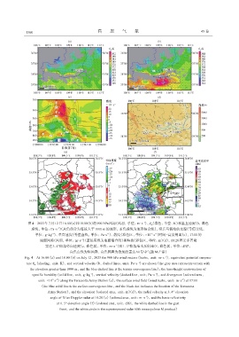
               图4 2023年7月12日16:00(a)和18:00(b)的900 hPa风场(风羽, 单位: m·s )、 θ(填色, 单位: K)和垂直速度(b, 黑色
                                                                          -1
                                                                              se
                              -1
                 虚线, 单位: Pa·s )(灰色部分为海拔大于1000 m的地形, 蓝色虚线为地形辐合线), 沿兵马俑站的比湿(等值实线,
                            -1
                                                                              -5
                                                        -1
                                                                                -1
                   单位: g·kg )、 垂直速度(等值虚线, 单位: Pa·s )、 散度(彩色区, 单位: ×10  s )时间-高度剖面(c), 17:00的
                                          -1
                     地面风场(风羽, 单位: m·s )(蓝色实线为地面辐合线)和海拔(彩色区, 单位: m)(d), 18:28西安多普勒
                                                            -1
                        雷达3. 4°仰角径向速度(e, 彩色区, 单位: m·s )和1. 5°仰角基本反射率(f, 彩色区, 单位: dBZ,
                                     白色点线为阵风锋, 白色圆圈为叠加的雷达60号中气旋M产品)
              Fig. 4 At 16:00 (a) and 18:00 (b) on July 12, 2023 the 900 hPa wind vectors (barbs, unit: m·s⁻¹), equivalent potential tempera‐
              ture θ  (shading, unit: K), and vertical velocity (b, dashed lines, unit: Pa·s⁻¹) are shown (the gray area represents terrain with
                   se
                the elevation greater than 1000 m, and the blue dashed line is the terrain convergence line); the time-height cross-section of
                                               -1
                                                                                -1
                  specific humidity (solid line, unit: g·kg ), vertical velocity (dashed line, unit: Pa·s ), and divergence (colored area,
                                                                                              -1
                            -5
                     unit: ×10  s ) along the Terracotta Army Station (c); the surface wind field (wind barbs, unit: m·s ) at 17:00
                              -1
                      (the blue solid line is the surface convergence line, and the black dot indicates the location of the Terracotta
                         Army Station), and the elevation (colored area, unit: m)(d); the radial velocity at 3. 4° elevation
                           angle of Xi'an Doppler radar at 18:28 (e) (colored area, unit: m·s ), and the basic reflectivity
                                                                           -1
                              at 1. 5° elevation angle (f) (colored area, unit: dBZ, the white dashed line is the gust
                                front, and the white circle is the superimposed radar 60th mesocyclone M product)

