


Page 142 - 《高原气象》2026年第5期
P. 142
高     原      气     象                                 45 卷
              1358
                         -1
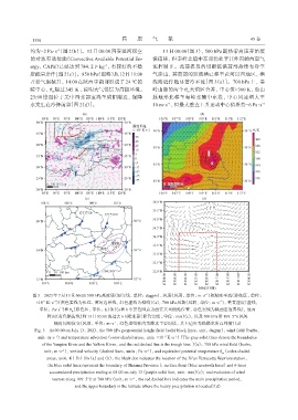
             约为-2 Pa·s [图 2(b)]。12 日 08:00 西安泾河探空                   13 日 00:00(图 3), 500 hPa 副热带高压开始缓
             的对流有效位能(Convective Available Potential En‐         慢南移, 但秦岭北麓中东部仍处于其外围的西南气
                                            -1
             ergy, CAPE)已经达到 784. 2 J·kg , 有较好的不稳               流控制下。此前提及的切断低涡前部持续有冷空
             定能量条件[图2(c)]。850 hPa(图略)从12日11:00                  气渗出, 其前部的短波槽已移至黄河以西地区, 槽
             开始气温猛升, 14:00 在陕西中南部形成了 24 ℃的                      线附近伴随显著冷平流[图 3(a)]。700 hPa 上, 秦
             暖中心, θ 超过 345 K, 说明大气低层为高能环境。                      岭山脉的两个 θ 大值区合并, 中心值>360 K, 沿山
                                                                              se
                      se
             23:00 锋面位于关中西北部宝鸡至咸阳附近, 强降                         脉地形北移至秦岭北麓中东段, 中心风速增大至
             水发生在冷锋前部[图2(d)]。                                   10 m·s 、 但最大垂直上升运动中心值维持-6 Pa·s               -1
                                                                      -1


                                                                                     -1
              图3 2023年7月13日00:00 500 hPa高度场(黑实线, 单位: dagpm)、 风场(风羽, 单位: m·s )和温度平流(彩色区, 单位:
                                                                                           -1
                   -5
                       -1
                ×10  K·s )(灰色实线为长江、 黄河边界线, 红色虚线为槽线)(a), 700 hPa风场(风羽, 单位: m·s ), 垂直速度(虚线,
                 单位: Pa·s )和θ(彩色区, 单位: K)(b)(a和b中黑色圆点为西安兵马俑站位置, 蓝色实线为陕西省边界线), 地面
                          -1
                              se
                    锋面(蓝色锯齿线)和13日05:00的过去6 h降水量(紫色实线, 单位: mm)(c), 以及700 hPa沿109. 5°E风矢
                                                -1
                       随时间的演变(风羽, 单位: m·s , 红色虚线框内为降水主要时段, 其上边界为强降水所在纬度)(d)
               Fig. 3 At 00:00 on July 13, 2023, the 500 hPa geopotential height field (solid black lines, unit: dagpm), wind field (barbs,
                unit: m·s⁻¹) and temperature advection (color-shaded areas, unit: ×10⁻⁵ K·s⁻¹) (The gray solid lines denote the boundaries
                  of the Yangtze River and the Yellow River, and the red dashed line is the trough line. )(a); 700 hPa wind field (barbs,
                   unit: m·s⁻¹), vertical velocity (dashed lines, units: Pa·s⁻¹), and equivalent potential temperature θ  (color-shaded
                                                                                            se
                    areas, unit: K) (b) [In (a) and (b), the black dot indicates the location of the Xi'an Terracotta Warriors station,
                     the blue solid lines represent the boundary of Shaanxi Province]; surface front (blue sawtooth lines) and 6-hour
                     accumulated precipitation ending at 05:00 on July 13 (purple solid line, unit: mm)(c); and evolution of wind
                      vectors along 109. 5°E at 700 hPa (unit: m·s⁻¹, the red dashed box indicates the main precipitation period,
                                and the upper boundary is the latitude where the heavy precipitation is located)(d)

