


Page 233 - 《高原气象》2026年第4期
P. 233
4 期                      魏地博等:基于流域降水空间分布作用机制的降尺度研究                                         1163


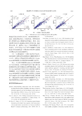
                                                   图7 不同源区月降水拟合效果
                                        Fig. 7 Different source area monthly precipitation fitting effect
                                                           2
               数据进行精度评估结果显示, MGWR 模型在 R 、                           1155/2014/928729.
               BIAS、 RMSE 指标均优于 GWR 模型。两种模型的                     Duan  Zheng,  Liu  Junzhi, Tuo Ye,  et  al.,  2016.  Evaluation  of  eight
                                                                    high spatial resolution gridded precipitation products in Adige Ba‐
               降尺度结果与站点数据均有所偏差。然而, MG‐
                                                                    sin (Italy) at multiple temporal and spatial scales[J]. Science of
               WR 降尺度结果与地面站点的拟合程度更高, 偏差
                                                                    the Total Environment, 573: 1536-1553. DOI: 10. 1016/j. scito‐
               程度更低, 在一定程度上校正了 TRMM 降水产品                            tenv. 2016. 08. 213.
               的误差。在年尺度上对比干旱年与湿润年尺度转                             Jeong D I, St-Hilaire A, Ouarda T B M J, et al., 2012. Multisite sta‐
               换前后降水剖面线进一步体现 MGWR 降尺度精度                             tistical  downscaling  model  for  daily  precipitation  combined  by
               及对降水空间分布的高解析力。                                       multivariate multiple linear regression and stochastic weather gen‐
                                                                    erator[J]. Climatic Change, 114(3): 567-591. DOI: 10. 1007/
                  (3)  三江源流域的三个源区地形差异显著,
                                                                    s10584-012-0451-3.
               MGWR 降尺度模型的结果整体拟合精度均较高(R                     2
                                                                 Meng Hongjie, Chu Lin, Wang Pengcheng, et al., 2025. Precipitation
               >0. 85), 说明在不同地形条件及降水区下 Geode‐                       drives latitudinal patterns of multifaceted biodiversity in montane
               tector-MGWR降尺度均能获得较好的降尺度结果。                          forests,  South-Central  China[J].  Ecological  Indicators,  171:
                   综上, 本文提出的使用 Geodetector分析流域降                     113246. DOI: 10. 1016/j. ecolind. 2025. 113246.
               水空间分布机制, 以科学选取环境因子输入降尺度                           Mirones Ó, Bedia J, Herrera S, et al., 2025. Refining remote sensing
                                                                    precipitation datasets in the South Pacific with an adaptive multi-
               模型能得到有效且精准的高分辨率降水数据, 并提
                                                                    method  calibration  approach[J].  Hydrology  and  Earth  System
               升了复杂地形条件下降水空间分布的细节刻画和
                                                                    Sciences, 29(3): 799-822. DOI: 10. 5194/hess-29-799-2025.
               预测精度。对比了两种模型的降尺度效果, Geode‐                        Moazami S, Na W, Najafi M R, et al., 2022. Spatiotemporal bias ad‐
               tector-MGWR降尺度框架的降尺度效果在三江源流                          justment of IMERG satellite precipitation data across Canada[J].
               域不同地形区的空间细节和降水量预测上更为精                                Advances in Water Resources, 168: 104300. DOI: 10. 1016/j. ad‐
               准, 为复杂地形区域高分辨率降水数据的生成、 区                             vwatres. 2022. 104300.
                                                                 Sun Yongjian, Deng Kefeng, Ren Kaijun, et al., 2024. Deep learning
               域水资源管理及生态保护提供了可靠的科学支持。
                                                                    in statistical downscaling for deriving high spatial resolution grid‐
               参考文献(References):                                    ded meteorological data: a systematic review[J]. ISPRS Journal
                                                                    of Photogrammetry and Remote Sensing, 208: 14-38. DOI: 10.
               Arshad A, Zhang Wanchang, Zhang Zhijie, et al., 2021. Reconstruct‐  1016/j. isprsjprs. 2023. 12. 011.
                  ing high-resolution gridded precipitation data using an improved   Wang Hongxiang, Lan Jiaqi, Huang Lintong, et al., 2025. Longitudi‐
                  downscaling approach over the high altitude mountain regions of   nal path analysis of ecosystem water yield effects and its driving
                  Upper Indus Basin (UIB)[J]. Science of the Total Environment,   forces  in  the  Upper Yangtze  River  basin[J].  Ecological  Indica‐
                  784: 147140. DOI: 10. 1016/j. scitotenv. 2021. 147140.   tors, 172: 113273. DOI: 10. 1016/j. ecolind. 2025. 113273.
               Chen Jie, Zhang X J, 2021. Challenges and potential solutions in sta‐  Wang Lihong, Li Yuechen, Gan Yushi, et al., 2024. Reconstructing
                  tistical  downscaling  of  precipitation[J].  Climatic  Change,  165  high-resolution gridded precipitation data in the southwest China
                 (3): 63. DOI: 10. 1007/s10584-021-03083-3.         highland canyon area using an improved (MGWR) downscaling
               da  Silva A  G,  Santos  e  S  C  M,  2014.  Improving  regional  dynamic   method[J].  Science  of  the  Total  Environment,  948:  174866.
                  downscaling with multiple linear regression model using compo‐  DOI: 10. 1016/j. scitotenv. 2024. 174866.
                  nents principal analysis: precipitation over Amazon and northeast   Xu Shiguang, Wu Chaoyang, Wang Li, et al., 2015. A new satellite-
                  Brazil[J]. Advances  in  Meteorology,  2014:  928729.  DOI:  10.   based  monthly  precipitation  downscaling  algorithm  with  non-

