


Page 118 - 《高原气象》2026年第4期
P. 118
高     原      气     象                                 45 卷
              1048


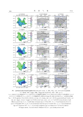
                   图2 各影响系统型的典型事件过程降水量(20:00至次日20:00, 左, 填色, 单位: mm)、 08:00 500 hPa位势高度
                                                                                           -1
                              (中, 等值线, 单位: dagpm, 间隔: 4 dagpm)和700 hPa风(右, 箭头, 单位: m·s )
             (a, b, c)2024年7月30日两高辐合型, (d, e, f)2019年9月10日局地低压/切变线型, (g, h, i)2015年10月9日冷空气主导的切变线型, (j, k, l)
                                                                                              -1
               2014年9月17日热带低压型, (m, n, o)2019年1月8日槽前降水型, 蓝线代表588 dagpm线, 蓝箭头表示风速≥12 m·s , 灰色阴影表示陆地
              Fig. 2 24 h Precipitation (from 20:00 to 20:00 the next day, left, shading, unit: mm), 500 hPa geopotential height (middle, con‐
                 tour, unit: dagpm, interval: 4 dagpm) and 700 hPa winds (right, arrow, unit: m·s ) at 08:00 for typical events of each
                                                                               -1
                 influencing system type.(a, b, c) double-high convergence type on 30 July 2024, (d, e, f) local low-pressure/shear line
                 type on 10 September 2019, (g, h, i) cold air-dominated shear line type on 9 October 2015, (j, k, l) tropical depression
                     type on 17 September 2014, (m, n, o) pre-trough precipitation type on 8 January 2019. The blue line indicates
                             588 dagpm contour, blue arrows denote wind speed ≥12 m·s , gray shading indicates land
                                                                         -1

