


Page 239 - 《高原气象》2026年第3期
P. 239
3 期                      余文梅等:宁夏特大暴雨异常环流极端性特征及概念模型                                         847


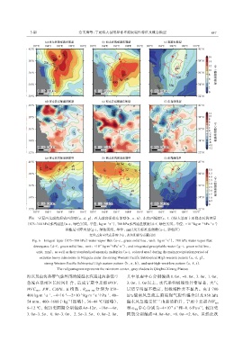
                图6 宁夏西太副高强盛西部型(a、 d、 g)、 西太副高强盛东部型(b、 e、 h)、 东高西低型(c、 f、 i)特大暴雨主要降水时段整层
                                                                                                             -1
                                                                                                           -1
                                                                                                      -2
                                                                                                 -6
                                                         -1
                                                       -1
              (875~300 hPa)水汽通量(a~c, 绿色实线, 单位: kg‧m ‧s )、 700 hPa水汽通量散度(d~f, 绿色实线, 单位: ×10  kg‧m ‧hPa ‧s )
                                  和整层可降水量(g~i, 绿色实线, 单位: mm)及其标准差倍数(a~i, 彩色区)
                                              红色五角星代表暴雨中心, 灰色阴影为青藏高原
                                                                                    -1
                 Fig. 6 Integral layer (875~300 hPa) water vapor flux (a~c, green solid line, unit: kg‧m ‧s ), 700 hPa water vapor flux
                                                                                      -1
                                                            -1
                                                              -1
                  divergence (d~f, green solid line, unit: ×10  kg‧m ‧hPa ‧s ), and integrated precipitable water (g~i, green solid line,
                                                        -2
                                                   -6
                   unit: mm), as well as their standardized anomaly multiples (a~i, colored area) during the main precipitation period of
                     extreme heavy rainstorms in Ningxia under the strong Western Pacific Subtropical High western pattern (a, d, g),
                       strong Western Pacific Subtropical High eastern pattern (b, e, h), and east-high-west-low pattern (c, f, i).
                              The red pentagram represents the rainstorm center, gray shadow is Qinghai-Xizang Plateau
               海以及南海热带气旋外围的暖湿水汽通过两条低空                            其中暴雨中心分别偏强 8. 0σ、 -8. 0σ、 3. 0σ、 1. 0σ、
               急流在暴雨区长时间汇合, 造成宁夏中北部 WVF、                         3. 0σ、 1. 0σ 以上, 水汽条件极端性异常显著, 大气
               WVC 、 PW、 CAPE、 K 指数、 θ      se850-500  分别为 150~  层结呈明显不稳定, 但极端性并不显著。由于 700
                   700
                                                       -1
                         -1
                       -1
               400 kg‧m ‧s 、 -4×10 ~-2×10  kg‧m ‧s ‧hPa 、 48~    hPa 偏南风急流左前端强气旋性辐合以及 850 hPa
                                 -6
                                                  -1
                                               -2
                                         -6
                                   -1
               54 mm、 400~1600 J·kg (图略)、 36~44 ℃(图略)、           偏东风急流受贺兰山强迫抬升, 宁夏中北部 DIV                    850
                                                                                                      -1
               6~12 ℃, 较历史同期分别偏强 4σ~12σ、 -10σ~-4σ、               和 ω 中心分别为-4×10  s 和-0. 6 Pa·s , 较历史
                                                                                          -1
                                                                                       -5
                                                                     700
               3. 0σ~3. 5σ、  0. 0σ~3. 0σ、  2. 5σ~3. 5σ、  0. 0σ~2. 0σ,   同期分别偏强-4. 0σ~0σ、 -8. 0σ~-2. 0σ。虽然此次

