


Page 193 - 《高原气象》2026年第3期
P. 193
3 期                    高焕昕等:基于WRF-SFIRE模式的华北地区局地林火模拟研究                                     801


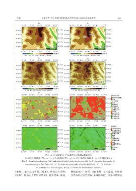
                                          图2 d04区域原始(左)与更新后(右)的静态数据分布
                       (a, b)为气象场海拔(单位: m), (c, d)为火场海拔(单位: m), (e, f)为土地利用类型分布, (g, h)为燃料类型分布
                     Fig. 2 Distribution of original (left) and updated (right) static data for area d04.(a, b) shows the topography of
                        the meteorological field (unit: m), (c, d) shows the topography of the fire field (unit: m), (e, f) shows
                                 the distribution of land-use types, and (g, h) shows the distribution of fuel types
              (密林), 灌木定为类别 5(灌木), 草地定为类别 1                       稀疏植被区、 冰雪、 开阔水域、 草木湿地、 红树林
              (低草), 耕地定为类别 3(高草), 建筑用地、 裸地、                      及苔藓均定为类别 14(不可燃物质), 具体可燃物信

