
Page 48 - 《高原气象》2021年第5期
P. 48
5 期 张俊兰等:青藏高原天气系统对昆仑山北坡一次罕见暴雨过程影响分析 1009
-5
坡冷平流区逐渐西扩,高中心值由-12×10 ~-8× 以上结果与内陆分析强降水、暴雪以及雨雪相态转
-5
-1
-1
-5
-5
10 ℃·s 降至-26×10 ~-20×10 ℃·s ,印证冷垫 换得出的结论(刘勇,2016;张芹,2015;赵桂香,
强度增强、范围扩大。 2011;周晋红,2014;赵宇,2018)基本一致。
低层东风携带湿空气在昆仑山北坡产生水汽
输送,使东风“冷垫”近地层形成“湿冷垫”,暖湿空 6 环流形势及天气系统的空间配置
气沿其爬升过程中空气增湿、冷却达到饱和,使降 此次暴雨是在有利的大尺度环流背景下、不同
水持续并出现增幅;中高层偏南暖湿气流与低层东 层次多个天气系统相互配合、共同作用产生的,图7
风“冷垫”在昆仑山北坡交汇,垂直方向加剧了冷暖 给出了昆仑山北坡暴雨环流形势及多个天气系统
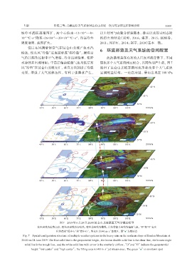
交绥,增强了大气的斜压性,有利于强降水产生, 空间配置结构。一是在高层,暴雨出现在 100 hPa
图7 2019年6月24日20:00昆仑山北坡暴雨天气学概念模型
蓝色实线为位势高度,棕色双实线为切变线,棕色单实线为槽线,白色带箭头实线为偏南气流,“D”和“G”表示
-1
位势高度“低中心”和“高中心”,填充区为≥40 m·s 急流区,绿“●”为暴雨点
Fig. 7 Spatial configuration structure of multiple weather systems in the heavy rain on the northern slope of Kunlun Mountain at
20:00 on 24 June 2019. The blue solid line is the geopotential height,the brown double solid line is the shear line,the brown single
solid line is the trough line,and the white solid line with arrow is the southerly airflow,“D”and“G”indicate the geopotential
-1
height“low center”and“high center”,the filling area is ≥40 m·s jet stream area,The green“●”is rainstorm spot